
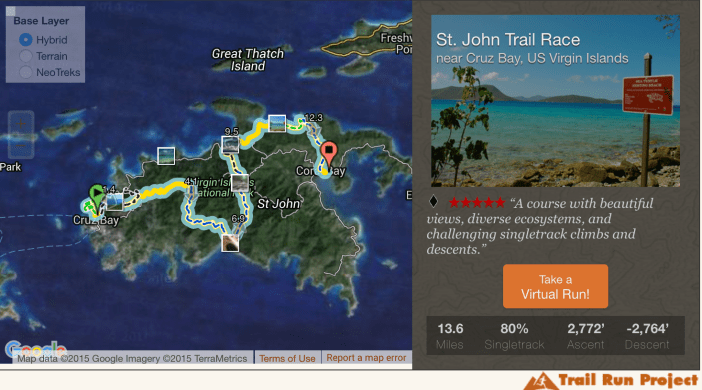
The course is between Cruz Bay and Coral Bay, predominantly on trails, with a distance of 13.6 miles and an elevation gain of 2,772 feet (detailed map with flythrough)

The course is technically challenging with several steep ascents and descents on very rugged trails.
This will largely be a self-supported race: runners are responsible for carrying their own water (one bottle required) and navigating the course which will only have markings at key junctions. Runners unfamiliar with the trails will need to study the detailed trail maps.
There are several transition checkpoints across roads that will have coolers to stash extra water and supporters can also wait there to cheer runners along. The longest segment between checkpoints is 4.5 miles (Fish + Reef Bay). There are several public toilets along the route, including at miles 0, 2.5, 7, 9, and 11.
The maximum time for this race will be 4.0 hours. As a guide to estimating your time,  assume it will take 2.5 times as long as the 8 Tuff Miles (see trendline in the 2016 results). With that in mind, we suggest that you should have less than a 95 minute recent finish or equivalent. This cutoff is intended to avoid taxing our volunteers or St. John Rescue in their sweep of the course.
The finish line and post-race celebration and awards ceremony will be at Skinny Legs in Coral Bay.
Use the following map for a flythrough “Virtual Run” of the course:

Lind Point Trail

Caneel Hill Lookout
Also see this trail running video with this lookout at 10:45.

Margaret Hill
 Reef Bay Beach

Reef Bay Trail

Maho Bay Beach

Leinster Bay Trail

Johnny Horn Outlook
